Plan for Walton 2040: What Residents Need to Know
Walton County’s 2040 plan uses sector maps and place types to manage growth, protect coasts, and invite resident feedback.
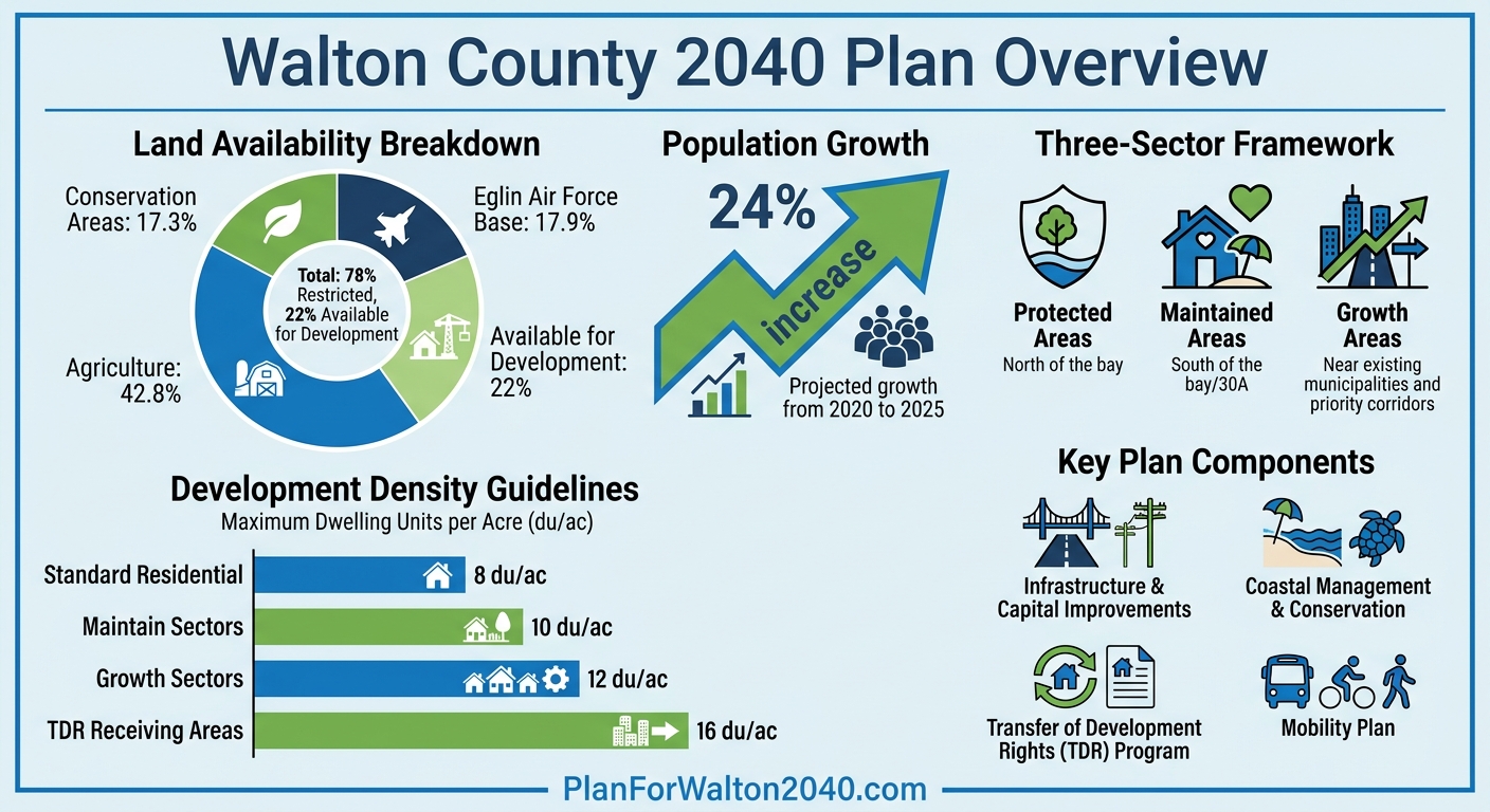
The Walton 2040 Plan is a roadmap for managing growth in Walton County while preserving its historical character. With the population projected to grow by nearly 24% from 2020 to 2025, the plan focuses on balancing development with infrastructure, public services, and natural resource conservation. Key highlights include:
- Growth Management: A new Sector Map divides the county into "Growth" and "Maintain" zones, guiding where higher-density development can occur.
- Land Use Updates: Introduction of "Place Types" to better reflect area-specific development goals, with density limits ranging from 8 to 16 dwelling units per acre based on location.
- Infrastructure and Transportation: Specific projects aim to ease congestion and improve connectivity, with a focus on sustainable development.
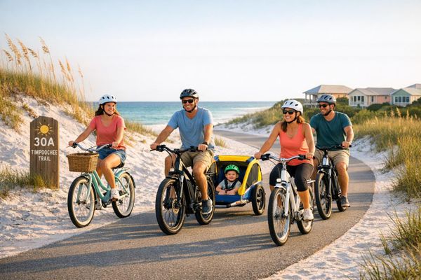
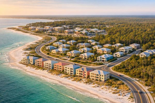
- Coastal Conservation: Efforts to protect sensitive areas while managing growth along 30A and South Walton.
- Resident Involvement: Opportunities for public feedback through workshops, online resources, and direct communication with the planning team.
The plan reflects extensive community input and aims to align economic growth with quality of life. For more information, visit PlanForWalton2040.com.
Walton County 2040 Plan: Land Use Distribution and Development Density Guidelines
Walton County approves 5-year infrastructure work plan
sbb-itb-d06eda6
Main Goals and Plan Components
The Walton 2040 Plan tackles a pressing question: "How do we shape Walton County's evolving growth?". Its approach focuses on managing development strategically, coordinating infrastructure needs, and maintaining the county's distinct identity.
As highlighted in the plan, "record growth in Walton County has created tremendous opportunities for jobs and economic development. However, this growth must go hand-in-hand with funding essential community services, infrastructure, and public safety". To address this, the plan links development approvals directly to infrastructure capacity, ensuring that services expand alongside population growth.
The plan's implementation revolves around two key components: Infrastructure and Capital Improvements and Coastal Management and Conservation. The Infrastructure component, detailed in documents released on May 9, 2025, specifies the projects required to support the county’s growing population. On the other hand, the Coastal Management component emphasizes safeguarding natural resources while managing growth in the county's environmentally sensitive coastal areas.
Land Use Changes and Recommendations
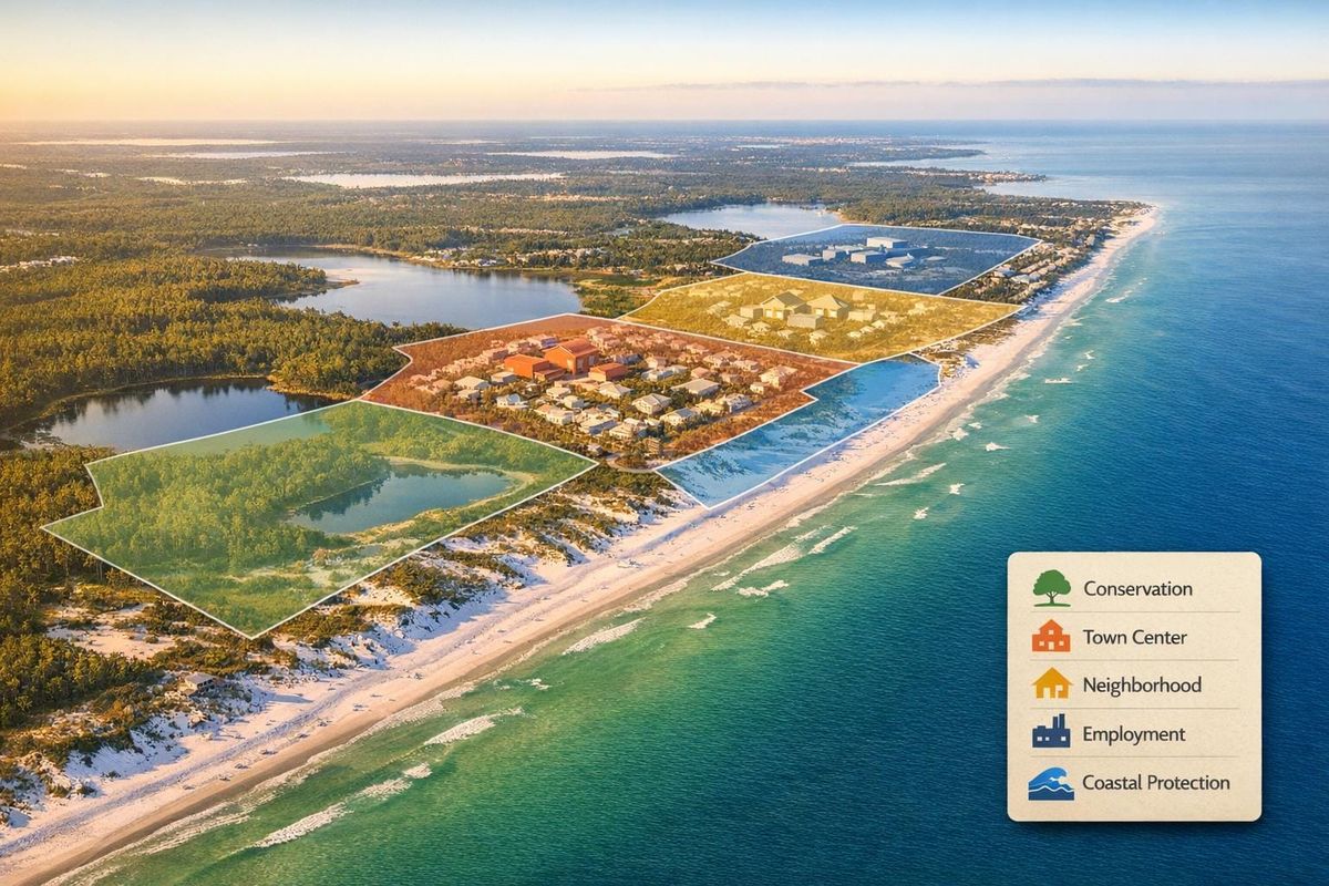
A newly introduced Sector Map divides Walton County into zones with tailored guidelines, replacing traditional Future Land Use categories with "Place Types" that better reflect the desired character of each area. These zones are categorized into "Growth" sectors, which encourage higher-intensity development, and "Maintain" sectors, which focus on preserving the county’s existing character.
- Growth sectors allow for a maximum density of 12 dwelling units per acre (du/ac).
- Maintain sectors are capped at 10 du/ac.
- The standard maximum density for Residential Future Land Use is set at 8 du/ac.
In the northern part of the county, the plan promotes rural clustering, concentrating development near commercial hubs while preserving the surrounding village-like atmosphere.
Another pivotal feature is the Transfer of Development Rights (TDR) program, which allows property owners in designated "sending areas" to sell density credits to developers in "receiving areas." The goal, according to the Plan for Walton Team, is to "transfer density credits from areas limiting development to those promoting higher intensities". In receiving areas, maximum density can reach 16 du/ac.
These strategies are complemented by a strong focus on transportation improvements to support sustainable growth.
Transportation and Mobility Improvements
To address the transportation challenges posed by rapid population growth, Walton County has a dedicated Mobility Plan, managed by the Planning and Development department. The Infrastructure and Capital Improvements component, updated in May 2025, identifies specific projects aimed at easing congestion and improving connectivity.
Jim Tucker from the Plan for Walton Team emphasized the importance of this approach, stating that "these two principles [housing and recreation] are critical in preserving neighborhood character and ensuring sufficient public and recreational spaces". By prioritizing mobility improvements, the Walton 2040 Plan ensures that transportation solutions align with the broader goal of balancing growth with the community's unique character.
How Residents Can Get Involved
Walton 2040 encourages residents to actively participate in shaping the county's future by providing feedback during every stage of the planning process.
One recent opportunity for public engagement occurred on June 20, 2025, when the planning team shared materials from a public workshop. These events give residents the chance to review data, ask questions, and share their thoughts on proposed changes. The Board of County Commissioners (BOCC) has also shown strong backing for the initiative, voting unanimously to approve the latest Walton 2040 report. For updates and resources, residents can visit the official website.
Tools and Resources for Participation
The central hub for Walton 2040 is www.PlanForWalton2040.com, where residents can find tools and resources to stay informed and involved. The "News & Events" section highlights updates on key plan areas, such as Infrastructure and Capital Improvements as well as Coastal Management and Conservation. Notably, information on Coastal Management was published on May 6, 2025.
The website also provides access to archived materials from past workshops, allowing residents to see how community input has influenced the plan's evolution. Slide presentations approved by the BOCC offer a clear, visual summary of the plan's current direction.
Additionally, residents can subscribe to email updates to stay informed about public meetings, surveys, and project milestones. Your feedback plays a vital role in guiding decisions on land use and transportation, helping to maintain Walton’s distinct character.
Contacting the Planning Team
For questions or feedback, residents have several ways to reach the planning team. You can send an email to info@PlanForWalton2040.com. The website also features a "Get in Touch" section where you can submit questions, share concerns, or offer suggestions.
How Residents Can Shape Future Development
Your voice matters when it comes to shaping Walton County's future. Over the next 15 years, residents have multiple opportunities to influence decisions on land use, infrastructure, and transportation before these proposals become official policy.
Influencing Land Use and Growth Decisions
To get a clear picture of Walton County's proposed developments, start by reviewing the official slide presentation. This presentation, made available after the early 2026 BOCC approval, outlines key plans for the county's future.
Dive deeper into the Preliminary Sector Map, available online, and attend workshops at the South Walton County Annex (31 Coastal Centre Blvd, Santa Rosa Beach). These workshops focus on "Place Types", which are specific areas designated for discussion on land use. This is your chance to share local knowledge and discuss priorities like housing, recreation, and conservation.
If you’re passionate about issues like affordable housing or preserving green spaces, you can submit targeted feedback on specific reports. The planning team has already released recommendations on housing, recreation, coastal management, and infrastructure. Stay updated by visiting the official website. As Jim Tucker from Beach Fanatic explained:
Throughout this process, we've heard a lot about the need for affordable and attainable housing. We've also heard from you that this cannot come at the expense of adequate space for recreation and quality of life.
Just as land use feedback is critical, transportation planning also needs your input.
Contributing to Transportation Planning
Your firsthand knowledge of local transportation challenges is key to refining the county’s plans. Walton 2040 has developed a "Recommended network" of maps that outline future plans for various travel modes, including bike lanes, trails, and parking. Your feedback can shape these plans into something that truly serves the community.
If you missed the June 2025 Public Workshop, don’t worry - materials from the event are still available online. These resources show how community input has already influenced the direction of the transportation plan. Whether you attend meetings in person or engage online, highlight specific concerns like crossing Highway 98, the lack of bike paths, or top beach parking spots.
To share your thoughts, use the "Get in Touch" feature on the website, email info@PlanForWalton2040.com, or call 267-1955. For more formal input, consider offering testimony at BOCC meetings in DeFuniak Springs or Planning Commission meetings at the Freeport Commons boardroom. Your voice ensures that transportation issues are addressed effectively.
Expected Effects on Walton County Communities
With 78% of Walton County already restricted - 17.3% designated for conservation, 17.9% for Eglin Air Force Base, and 42.8% for agriculture - only 22% of the land is left for new development. This limited availability makes every decision about land use incredibly important for local communities. The Walton 2040 Plan is reshaping development in South Walton and along 30A, balancing growth with environmental care. Here's how these constraints are influencing strategies for economic development and preserving the county's character.
Economic Growth and Community Benefits
The Walton 2040 Plan focuses on improving land use and mobility to strengthen local economies while maintaining the unique character of neighborhoods. By identifying "Growth Areas" near existing municipalities and priority corridors, the plan encourages walkable, mixed-use developments that support local businesses and avoid urban sprawl. As the Plan for Walton Team explains:
This place-based approach helps align policies and investments with local needs, ensuring that growth supports economic sustainability, environmental stewardship, and community identity.
Another key feature is the introduction of "Place Types", which provides developers and business owners with clear guidelines for the character and intensity of future projects, making the planning process more straightforward. The county is also leveraging "Economics of Land Use" strategies to treat land as a financial asset, encouraging higher-value development patterns. Joe Minicozzi from Urban3 highlights the importance of this approach:
If citizens are the joint owners of the "corporation" that is Walton County, and policymakers are your Board of Directors, it's important to understand the [economics of land use].
These strategies, shaped by community input, aim to ensure that economic growth not only creates jobs and opportunities but also aligns with the priorities of Walton County residents.
Protecting the Environment and Local Lifestyle
Efforts to protect sensitive coastal areas and maintain Walton County's distinctive lifestyle have been heavily influenced by resident feedback. For those living along 30A and in South Walton, the plan designates these regions as "Maintained Areas" to safeguard the character of established neighborhoods. The county's three-sector framework divides the area into Protected Areas (north of the bay), Maintained Areas (south of the bay/30A), and Growth Areas, ensuring that high-intensity development is directed away from vulnerable coastal zones. As the official Plan for Walton 2040 website asks:
How can Walton County's quality of life be preserved, knowing that growth will continue?
The plan outlines specific recommendations for conservation, coastal management, and recreation, aiming to balance growth with the region's quality of life. By concentrating new development in targeted corridors, the plan protects the natural beauty and relaxed lifestyle that define Walton County. This approach is especially important for communities along 30A, where preserving the area's authentic charm is vital for both residents and visitors.
What Residents Should Know
After a 16-month planning process, the Walton 2040 Plan was approved by the Board of County Commissioners. With only 22% of Walton County open for new development - and 78% already designated for conservation, agriculture, or military purposes - every land use decision carries weight. This reality sets the stage for the plan's detailed guidelines.
The plan introduces a three-sector framework alongside a new "Place Types" system, offering clear development guidelines tailored to specific areas. As the Plan for Walton Team explains:
"How the county chooses to grow - and the strategies it employs to do so - will have a significant and lasting impact on its future."
Resident involvement is key to putting these guidelines into action. Tools like the Gridics Zoning Software, available on the plan's website, allow you to explore Place Type maps for your area. You can also stay informed by tracking upcoming Board of County Commissioners (BOCC) meetings and sharing your feedback through the "Get in Touch" feature.
The Walton 2040 Plan aims to balance economic growth with infrastructure needs, environmental conservation, and quality of life. By understanding the Place Types assigned to your neighborhood, you can play an active role in shaping Walton County's future.
FAQs
How can I find my property’s Place Type and sector on the map?
To find your property’s Place Type and sector, check the Bay-Walton Sector Plan map. This map highlights sector boundaries and expansion areas, making it easier to pinpoint your property’s classification. Additionally, Walton County’s comprehensive plan updates include visual aids that display Place Types. Simply match your property’s location to the map details for an accurate determination. These tools are part of the Walton 2040 planning process, which aims to shape future development in the area.
What does the Transfer of Development Rights (TDR) program mean for my land value and nearby density?
The Transfer of Development Rights (TDR) program allows landowners to shift development potential from one property to another. This approach can boost property value in designated receiving zones while lowering density in sending zones. By doing so, the program supports growth management and the protection of natural areas, striking a balance between development and environmental conservation.
What are the next deadlines and meetings where residents can still influence Walton 2040 decisions?
Residents will have the opportunity to shape Walton 2040 decisions by participating in workshops following the Planning Commission meeting on April 9. More workshops will be scheduled, and these events will provide chances for public input. Keep an eye out for updates on confirmed dates and times.