30A Coastal Construction Control Line Explained
What the CCCL means for 30A properties: how the line is set, permit and building requirements, rebuilding after storms, and how to check property status.
The Coastal Construction Control Line (CCCL) is a boundary set by Florida's Department of Environmental Protection (DEP) to regulate construction and protect the beach-dune system along 30A. If your property falls seaward of this line, you’ll face environmental building rules, including storm-resistant designs, elevated structures, and additional permits. Here’s what you need to know:
- Purpose: The CCCL ensures construction doesn’t harm beaches, dunes, marine life, or public access.
- Permits Required: Work seaward of the CCCL needs DEP approval via a "Notice to Proceed" or "Exemption Determination."
- Building Standards: Structures must withstand 100-year storms, use piling foundations, and meet elevation requirements.
- Location Updates: The CCCL is based on storm impact models, erosion projections, and shoreline changes.
- How to Check: Use DEP’s Map Direct tool or hire a certified surveyor to confirm if your property is within the CCCL.
Understanding these rules is crucial for property owners and developers along 30A to ensure compliance and protect Florida’s coastline.
ReliaBilt Windows 101: Coastal Building Codes for Windows

How the CCCL Is Set and Updated on 30A
The Florida Department of Environmental Protection (FDEP) uses advanced coastal engineering models and scientific research to determine the location of the Coastal Construction Control Line (CCCL) along 30A. As explained by the FDEP, "The CCCL location is based on coastal engineering models, survey and bathymetric data and scientific principles that determine the upland or landward extent of the damaging effects of a 100-year storm event". These boundaries are further refined using long-term projection data to ensure accuracy.
In addition to storm impact modeling, the FDEP calculates where the shoreline is likely to be 30 years into the future. This process, known as the 30-Year Erosion Projection (30-YEP), relies on historical records such as coastal surveys, aerial photography, and data from reference monuments. By analyzing these sources, the FDEP determines the average annual shoreline change rate, which is then multiplied by 30 years and applied landward from the current seasonal high water line. Even in areas where the shoreline appears stable or is gaining sand, the agency uses a conservative estimate of minus one foot per year to account for uncertainties.
Factors Used to Set the CCCL
To ensure precision, the FDEP incorporates a variety of data sources. These include bathymetric readings, topographic surveys, historical photographs, and measurements from coastal range monuments. For additional accuracy, calculations use data from at least three reference monuments on either side of a property to reflect localized erosion trends.
Human activities also play a role in shaping the CCCL. Beach nourishment projects, seawalls, and the influence of nearby inlets are factored into the erosion projections. For example, if a beach has been artificially restored, the FDEP considers the expected lifespan of that nourishment when predicting future shoreline changes. Similarly, if a seawall or other coastal armoring is present, the 30-year erosion projection may stop at the structure - provided a certified Florida-licensed engineer confirms it can withstand a 30-year storm event.
How Often the CCCL Is Updated
The CCCL is not reviewed on a fixed schedule but is updated when significant changes to the shoreline occur. Events like hurricanes, major storms, or severe erosion can trigger a reassessment. Between these updates, the FDEP continuously collects and maintains shoreline data through surveys and measurements. For individual properties, site-specific 30-year erosion projections are conducted when property owners submit permit applications, along with required topographic surveys.
How the CCCL Affects Property Owners and Construction on 30A
The Coastal Construction Control Line (CCCL) program plays a significant role in shaping how property owners and builders approach construction and renovations along the 30A coastline. Its regulations are designed to safeguard Florida's beaches and dunes, but they also impose detailed requirements that property owners must navigate.
Building Restrictions Seaward of the CCCL
For properties located seaward of the CCCL, construction standards are far more rigorous than in typical coastal zones. Structures must be built to withstand 100-year storm forces, meaning all habitable buildings, additions, and nearby pools need piling foundations and must be elevated above the Department of Environmental Protection's (DEP) 100-Year Storm Elevation. These measures ensure durability in the face of extreme weather conditions .
Before any work begins, Walton County requires property owners to obtain either a "Notice to Proceed" or an "Exemption Determination" from the DEP. Construction plans must be certified by a Florida-licensed professional, adhere to Florida Building Code Section 3109, and include two DEP Elevation Certificates - one submitted with the permit application and another after the lowest horizontal structural member is installed.
Permit Requirements for CCCL Properties
The type of permit required depends on the scope of the project. For major structures, property owners need an Individual Administrative Permit, while single-family homes situated landward of the dune system may qualify for a General Permit, which offers a simplified process with a 30-day approval window. Minor projects, such as decks or stairs, fall under Field Permits, and Emergency Permits are available for storm-related repairs. Permit durations differ: major projects are granted 3 years, minor ones 1 year, and other projects 2 years .
The CCCL program also regulates activities like excavation, removal of dune vegetation, and coastal armoring. Projects must comply with sea turtle protection guidelines outlined in Chapter 62B-55, F.A.C., which include providing a detailed marine turtle lighting plan for any permanent exterior lighting. Additionally, surveys submitted with applications must be signed, sealed, and dated within six months. Walton County must confirm local zoning compliance before the DEP grants final approval .
For property owners along 30A, understanding and adhering to these regulations is essential when planning construction or repairs seaward of the CCCL. These rules may feel complex, but they are critical for maintaining the integrity of Florida's coastline.
How to Check If a Property Falls Within the CCCL on 30A
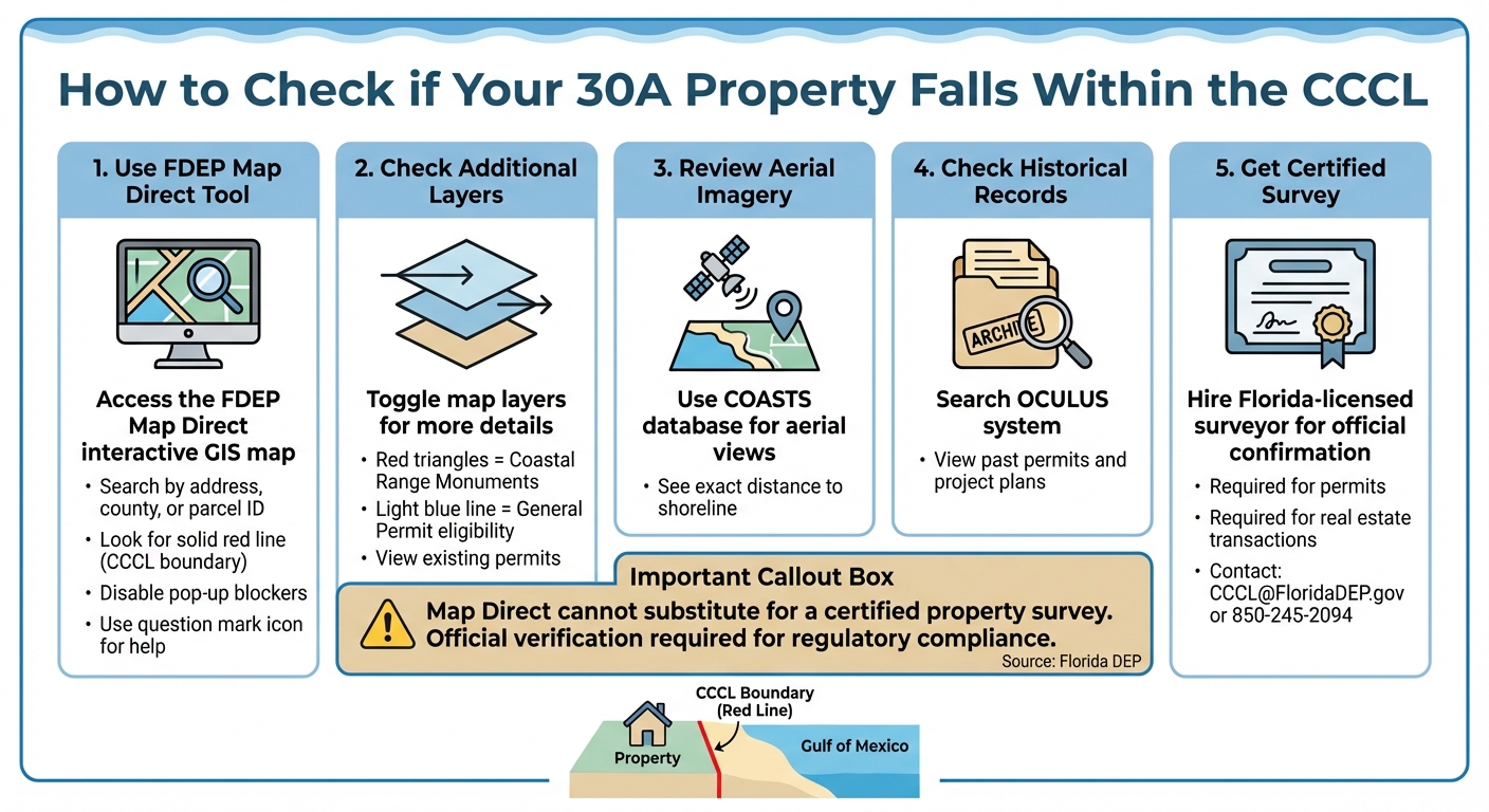
How to Check if Your 30A Property Falls Within the CCCL: Step-by-Step Guide
Before diving into construction plans or real estate deals, it’s crucial to determine if your property is located within the Coastal Construction Control Line (CCCL) on 30A. This step is essential for ensuring compliance with regulations that govern construction and property transactions in coastal areas. Thankfully, there are digital tools and professional resources available to make this process easier.
Using FDEP and Walton County GIS Tools
The FDEP Map Direct tool is one of the best resources for pinpointing the CCCL’s location in relation to your property. On this interactive GIS map, the CCCL appears as a solid red line. If your property sits between this line and the Gulf of Mexico - or if the line crosses your parcel - it falls under CCCL regulations.
Here’s how to use Map Direct:
- Search for your property by entering the street address, county, or parcel ID.
- Make sure pop-up blockers are turned off for the site to function properly.
- Use the question mark icon for guidance on navigating the map.
- Toggle layers to view additional details, such as Coastal Range Monuments (red triangles), existing permits, or a light blue line that shows where streamlined General Permits might apply for single-family homes.
For a more detailed view, the COASTS database provides aerial imagery to help you see exactly how close your property is to the shoreline. Additionally, the OCULUS system, the FDEP’s document management platform, allows you to look up existing permit applications, past project plans, and historical permitting documents for specific properties on 30A.
"Map Direct is a generic mapping tool and cannot substitute for a property and boundary survey. A certified survey is required to confirm regulatory jurisdiction." - Florida Department of Environmental Protection
While these tools are helpful for an initial assessment, a certified survey is necessary for official confirmation.
Obtaining a Certified CCCL Determination
Although GIS tools provide a great starting point, they can’t replace a certified survey when it comes to regulatory compliance. If you’re planning construction or involved in a 30A real estate transaction, you’ll need a Florida-licensed surveyor to verify the CCCL’s location. Walton County requires this step for issuing permits.
To get an official determination, you can:
- Contact the FDEP CCCL permit manager or a Walton County field inspector at 850-245-2094.
- Email inquiries to CCCL@FloridaDEP.gov.
Florida law also mandates that sellers disclose if a property is located seaward of the CCCL. This makes formal verification a critical step when comparing beachfront and gulf-view properties.
If your property is confirmed to be seaward of the CCCL, you’ll need to hire a Florida-licensed surveyor, engineer, or architect to prepare the necessary DEP Elevation Certificates.
For additional guidance on coastal construction regulations along 30A, visit sowal.co.
Rebuilding Storm-Damaged Homes Seaward of the CCCL
If your home on 30A is located seaward of the Coastal Construction Control Line (CCCL) in your chosen 30A neighborhood and has been damaged by a hurricane or tropical storm, you'll need approval from the Florida Department of Environmental Protection (DEP) before rebuilding. According to Florida law, securing a "Notice to Proceed" or an "Exemption Determination" from the DEP is required before Walton County can issue a permit. These steps are just the beginning of the rigorous rebuilding process.
Requirements for Repairs and Rebuilding
Rebuilding must align with Florida Building Code Section 3109, which ensures that structures can endure the forces of a 100-year storm. Homes, including additions and pools, must be built on a piling foundation. Additionally, the lowest horizontal structural member must be elevated above the DEP-designated 100-Year Storm Elevation.
A Florida-licensed engineer or architect is required to certify the plans and prepare two DEP Elevation Certificates: one during the permit application process and another after placing the lowest horizontal structural member. In the aftermath of a declared storm, the DEP may issue an Emergency Final Order (EFO), which allows local governments to expedite recovery by issuing emergency CCCL permits.
"Building Permits will not be issued for any work, including repairs and renovations, unless a 'Notice to Proceed' or an 'Exemption Determination' from DEP is submitted to the Building Department." – Walton County Government
Property owners can also request guidance by submitting a Post-Storm Permit Assistance Request Form through the CCCL program. If dune restoration is part of your recovery plan, any sand used must meet specific grain size and color standards to comply with beach compatibility requirements under Rule 62B-33.005, F.A.C..
Conclusion
The CCCL plays a crucial role in preserving 30A's coastline by enforcing strict construction standards. These regulations help protect native salt-tolerant plants, marine turtle nesting areas, and the beach-dune system, which acts as a natural defense against severe storms. By requiring buildings located seaward of the CCCL to endure 100-year storm conditions, the program minimizes the risk of structural damage and debris during extreme weather. This approach not only reduces construction risks but also provides a framework for making responsible property decisions along the coast.
For property owners, understanding your property's CCCL status is essential when planning to buy, build, or rebuild. This knowledge aids in ensuring safe construction practices and effective storm recovery strategies. To dive deeper, refer to the Homeowner's Guide to the CCCL Program and the CCCL Frequently Asked Questions provided by the Florida Department of Environmental Protection. If you're planning any construction or repairs, reach out to the CCCL permit manager or field inspector assigned to Walton County for tailored advice.