Building on 30A: Environmental Rules You Need to Know
Overview of permits, flood-elevation rules, dune and sea‑turtle protections, and pre-construction steps for coastal building on 30A.
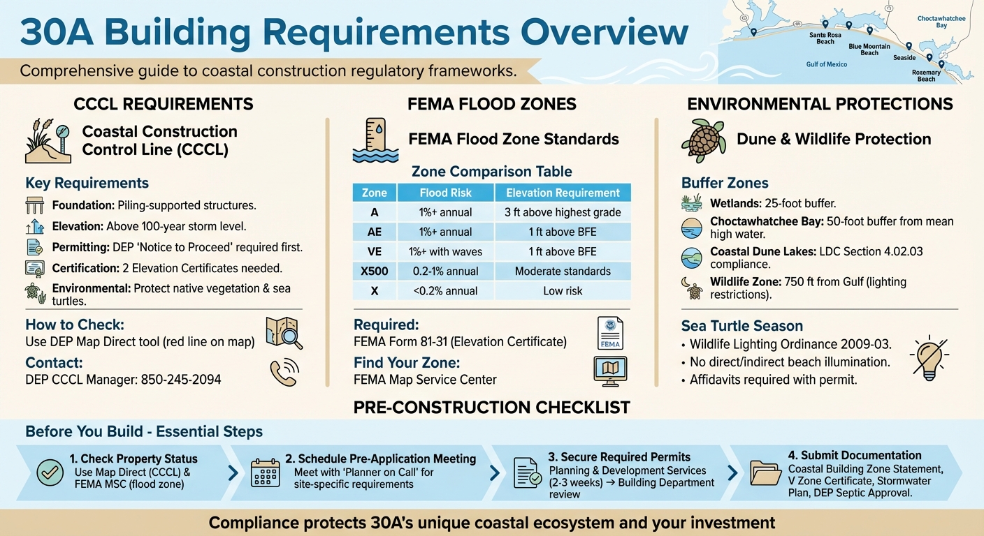
Building on 30A requires navigating strict rules to protect the area's fragile coastal ecosystem and ensure safe construction in storm-prone zones. Here's what you need to know:
- Coastal Construction Control Line (CCCL): If your property is seaward of the CCCL, you'll need a Florida DEP permit before starting construction. Use tools like the DEP's Map Direct to check your property's status.
- FEMA Flood Zones: Your flood zone determines elevation and design requirements. Properties in high-risk zones (like AE or VE) must meet specific standards, including building above the Base Flood Elevation (BFE).
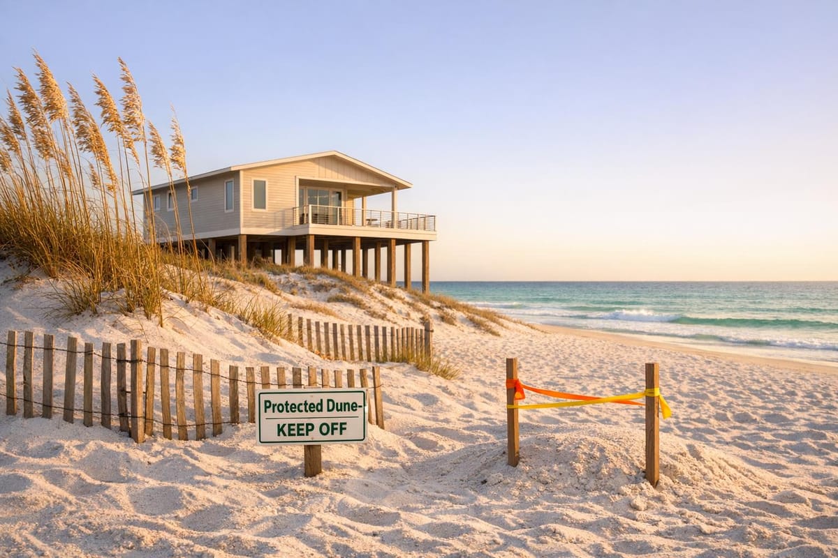
- Dune and Wildlife Protections: Buffer zones safeguard wetlands, dune systems, and sea turtle nesting areas. Unauthorized clearing or lighting violations can lead to fines.
- Pre-Construction Steps: Secure permits from Walton County and the Florida DEP, confirm zoning requirements, and schedule a pre-application meeting to address flood zones, setbacks, and stormwater management.
Compliance isn't just about avoiding fines - it helps preserve the unique beauty and resilience of the 30A coastline. Whether you're building a new home or renovating, following these rules ensures a smoother process and protects your investment.
30A Building Requirements: CCCL, FEMA Zones, and Environmental Protection Guide
Coastal Construction Control Line (CCCL) Requirements
The Coastal Construction Control Line (CCCL) is a boundary established by the Florida Department of Environmental Protection (DEP) to mark areas at risk during a 100-year storm event. This line is found in 25 coastal counties across Florida with sandy beaches, including Walton County. The CCCL plays a key role in protecting the fragile beach and dune systems while guiding construction efforts in these vulnerable zones.
It’s important to understand that the CCCL is not a restriction line. As the Florida DEP explains:
"The CCCL is not a seaward limit for construction of upland structures (as in a setback line), but is a jurisdictional area where special siting and design considerations are necessary to protect the beach and dune system, proposed or existing structures, adjacent properties, public beach access, native salt-tolerant coastal vegetation and marine turtles".
If your property is located seaward of the CCCL, additional permitting and design requirements will apply. Before you can begin any construction, excavation, or removal of native vegetation, you’ll need to secure a DEP permit, such as a "Notice to Proceed" or an "Exemption Determination." Only after obtaining this permit will Walton County issue a local building permit. The DEP evaluates projects based on their potential impact on the beach-dune system, nearby properties, vegetation, and marine turtles.
How to Check Your Property's CCCL Status
Finding out whether your property is seaward of the CCCL is simple. The Florida DEP offers Map Direct, an interactive GIS mapping tool that displays the CCCL as a solid red line over property boundaries. This tool is available online and can help you determine your property’s status before starting any design work.
For further verification, you can contact a CCCL field inspector through DEP district offices or reach out to the DEP CCCL permit manager for Walton County at 850-245-2094. Additionally, the DEP's OCULUS electronic document management system provides access to existing permits, project plans, and historical records for your property.
Confirming your property’s status is a crucial first step before planning construction. If your property is located seaward of the CCCL, you’ll need to follow specific structural and environmental guidelines.
Additional Requirements for Seaward Properties
For properties seaward of the CCCL, strict standards ensure both structural durability and environmental protection. These include designing buildings to withstand a 100-year storm event, as outlined in Florida Building Code Section 3109. Key requirements include:
- Piling foundations for all habitable structures, additions, and nearby pools.
- Elevating the lowest horizontal structural member above the DEP 100-Year Storm Elevation.
- Providing two Elevation Certificates (one at the permit application stage and another after placement) from a licensed surveyor.
- Certification of all structural plans by a Florida-licensed Engineer or Architect to confirm compliance with Florida Building Code Section 3109.
| Requirement | Standard |
|---|---|
| Foundation | Piling-supported (for habitable structures and nearby pools) |
| Elevation | Above the 100-year storm level |
| Permitting | DEP "Notice to Proceed" required before obtaining local permits |
| Certification | Two Elevation Certificates (at permit and placement) |
| Environmental | Protect native vegetation and sea turtle nesting areas |
For single-family homes located further inland but still seaward of the CCCL, a streamlined 30-day "General Permit" process may apply under Chapter 62B-34, F.A.C.. These measures help ensure that development along 30A not only meets structural standards but also respects the area’s natural environment, preserving its unique coastal ecosystem.
FEMA Flood Zones and Elevation Standards
If you're building along the coast in 30A, FEMA flood zones add another layer of construction rules to follow. These zones, determined by the annual likelihood of flooding, come with specific elevation and floodproofing requirements that must be met before Walton County will issue a building permit.
Your assigned flood zone impacts key aspects of construction like foundation design, floor height, and overall costs. On top of CCCL mandates, these FEMA standards are designed to protect your property from Gulf storms. For developments located in Special Flood Hazard Areas (SFHA), Walton County requires both a development order and a building permit. The applications are reviewed by the County Floodplain Manager to ensure compliance. Elevation requirements vary by zone, such as building 1 foot above the Base Flood Elevation (BFE) in Zone AE or 3 feet above the highest adjacent grade in Zone A, where no BFE has been determined. These guidelines, like those of the CCCL, aim to safeguard structures against extreme weather conditions.
Finding Your FEMA Flood Zone
To identify your FEMA flood zone, the FEMA Flood Map Service Center (MSC) is your go-to resource. Their website offers tools like "Search by Address" or "Search All Products" to locate your property's flood map and zone designation.
Here’s a quick overview of the most common zones:
- Zone A/AE/VE: Areas with a 1% or higher annual chance of flooding.
- Zone X500: Areas with a 0.2% to 1% annual chance of flooding.
- Zone X: Areas with less than a 0.2% annual chance of flooding.
| Flood Zone | Annual Probability of Flooding | Description |
|---|---|---|
| A | 1% or greater | 100-year flood; BFE not determined. |
| AE | 1% or greater | 100-year flood; BFE determined. |
| VE | 1% or greater | 100-year flood with wave action; BFE determined. |
| X500 | 0.2% to 1% | Between 100-year and 500-year flood limits. |
| X | Less than 0.2% | Outside 500-year floodplain; low risk. |
Once you identify your zone, use the MSC's "Search All Products" feature to check for any Letters of Map Change (LOMC) issued for your area. If you're in Zone A and no BFE has been established, property owners with parcels smaller than 5 acres or 50 lots can submit a BFE Determination Form to Walton County for verification.
Elevation Certificates and Drainage Plans
After confirming your flood zone, you'll need to meet Walton County's elevation and drainage requirements. An Elevation Certificate (FEMA Form 81-31) is required to prove your construction complies with elevation standards. For new builds, this certificate must be submitted at three stages during construction.
Here’s how elevation standards differ by zone:
- Zone AE: Living areas must be at least 1 foot above the BFE.
- Zone VE and Coastal A Zones: The lowest horizontal structural member must be at least 1 foot above the BFE.
- Zone A (no BFE): Finished floors must be at least 3 feet above the highest adjacent grade.
Non-residential buildings in Zones AE and A can opt for floodproofing instead of elevation, but this requires a certified Floodproofing Certificate (FEMA Form 81-65).
For areas below the BFE, Walton County mandates a Non-Conversion Agreement to prevent future conversion into living spaces. Any fill added to single-family lots in an SFHA must be approved by the Floodplain Manager and follow a "no-adverse impact" approach, ensuring water isn't redirected to neighboring properties. If your project is in a regulatory floodway, you'll also need a No-Rise Certification from a professional engineer to confirm that it won't alter the 100-year flood level (resulting in a 0.00-foot change).
Lastly, projects that involve altering the landscape or adding fill require county-approved drainage plans. These plans are essential to manage stormwater effectively and reduce flood risks.
Walton County and State Permits
Once you've met FEMA requirements, the next step is a two-part approval process with Walton County. First, Planning and Development Services reviews your site plan, building location, stormwater management, and foundation details. This process typically takes 2 to 3 weeks. After that, the Building Department ensures your project complies with the Florida Building Code. These permits also address measures to protect the coastal environment, which are outlined below.
Before clearing any land south of Choctawhatchee Bay, you must obtain a building permit or development order. This rule is in place to safeguard the native vegetation and wildlife that give 30A its character. For properties north of the bay, a separate land clearing permit is required, which comes with a $25 application fee. Ignoring these requirements can lead to fines and mandatory restoration.
"Walton County's Coastal Dune Lakes are not only rare and unique, they are a very important component of our community and as such are protected by strong regulation."
– Walton County Planning Department
It's a good idea to schedule a pre-application meeting with the Planning Department early in the process. Their "Planner on Call" service can help clarify requirements related to wetlands, setbacks, or stormwater management. This is especially useful before buying land or finalizing any designs. Additionally, the Walton County Interactive Map is a helpful tool for checking zoning districts and FEMA flood designations to identify potential challenges.
Dune and Vegetation Protection Rules
Walton County enforces strict buffer zones to protect the coastal ecosystem. These include:
- A 25-foot buffer from wetlands.
- A 50-foot buffer from the mean high water line of Choctawhatchee Bay and its tributaries.
- For properties near Coastal Dune Lakes, compliance with LDC Section 4.02.03, which prohibits vegetation clearing in protected areas.
| Protection Zone | Required Buffer/Requirement | Authority |
|---|---|---|
| Wetlands | 25-foot natural buffer | Walton County Planning |
| Choctawhatchee Bay | 50-foot buffer from mean high water line | Walton County Planning |
| Coastal Dune Lakes | Compliance with LDC Section 4.02.03 | Walton County Planning |
| Seaward of CCCL | DEP permit for structures/dune impact | Florida DEP |
Before removing trees or native vegetation, always confirm with county officials. While you might get approval to remove dead or diseased trees, unauthorized clearing in protected zones can result in steep penalties and costly restoration. For construction seaward of the CCCL, state permits are essential to protect the beach-dune system, sea turtles, and native dune plants.
Accessory structures, such as decks, sheds, or porches, located within the Coastal Building Zone (south of the bay) require building permits, regardless of size. However, detached non-habitable structures under 400 square feet may be exempt from permits in areas north of the bay.
Sea Turtle Nesting Season Restrictions
If your project is within 750 feet of the Gulf's Mean High Water Line, it falls under the Wildlife Conservation Zone and must comply with the Wildlife Lighting Ordinance (No. 2009-03). As part of your building permit application, you'll need to submit a wildlife lighting review along with the "Wildlife Lighting Notification Affidavit" and "Wildlife Lighting Installation Affidavit." Your lighting plan must ensure no light - direct or indirect - reaches the beach.
"Property owners are responsible for ensuring that all lighting along the beach is controlled so as not to directly or indirectly illuminate the beach."
– Walton County Board of County Commissioners
The Florida Beaches Habitat Conservation Plan (HCP) also sets additional wildlife protection standards for coastal construction in 25 Florida counties, including Walton County. These guidelines help mitigate risks to sea turtles. Be sure to consult the Florida Fish and Wildlife Conservation Commission (FWC) for any construction timing restrictions during nesting season. If your property is subject to CCCL regulations, additional measures are in place to protect sea turtle habitats. Coordinate with the Walton County Environmental Manager or Planning Department before making any changes to land near sensitive areas.
Pre-Construction Compliance Steps
Getting through the pre-construction phase involves a two-step approval process. First, the Planning and Development Services Department reviews your site plan. They’ll assess key factors like building height, foundation type, flood zone requirements, and finish floor elevation. This review typically takes 2 to 3 weeks. Once that’s complete, the Building Department conducts a structural compliance check. Keep in mind that any projects submitted after December 31, 2023, must follow the 2023 Florida Building Code standards. Afterward, you’ll need to coordinate with county officials to address specific zoning and environmental requirements for your site.
Pre-Application Meetings with ARB and County Officials
One of the first steps to streamline the process is scheduling a pre-application meeting with the "Planner on Call." These meetings are invaluable. County planners will walk you through critical details such as flood zones, wetlands, setbacks, and stormwater requirements tailored to your property. If your lot is within the Route 30A Scenic Corridor Overlay District, you’ll also need to comply with stricter standards for landscaping, signage, and access, as outlined in Section 6.10.00 of the Land Development Code.
"We encourage talking to the Planner on Call when thinking of purchasing a lot or land to build on. Ask questions about flood zone, wetlands, specific development or subdivision related requirements, stormwater requirements, setbacks…anything!"
– Walton County Planning Department
To double-check your property’s details, use the county map. If your lot is near a Coastal Dune Lake, you’ll need to follow Section 4.02.03, which restricts vegetation clearing in protected areas unless prior approval is granted. During your pre-application meeting, confirm if there are any additional Scenic Corridor or setback requirements that might apply to your project.
Once you’ve clarified all zoning and environmental requirements, hiring local experts can help simplify the compliance process.
Working with Local Compliance Experts
Under Ordinance 2023-28, Walton County allows you to hire licensed Private Providers for plan reviews and inspections. This option can be particularly helpful for complex projects, especially those located seaward of the Coastal Construction Control Line, which require specialized knowledge under Florida Administrative Code 62B-33.
Before you break ground, you’ll need to secure several key documents, including:
- Coastal Building Zone Statement
- V Zone Certificate for high-risk flood zones
- DEP Septic System Approval Disclosure (if your property isn’t connected to central sewer)
- Stormwater Management Plan
These documents ensure your project meets both local and state guidelines. Walton County’s Building Permit Checklist is a helpful resource for identifying certifications that require a licensed professional’s seal, such as Pile Installation Forms or Owner Wind Certifications. For properties in flood-prone areas, it’s also crucial to consult floodplain management requirements to stay compliant with the National Flood Insurance Program (NFIP) and the Flood Prevention Ordinance 2010-08.
Conclusion
Building on 30A is about more than just creating your dream home - it's about protecting the treasured coastal landscapes that make the area so special. These regulations aren't just bureaucratic hurdles; they're essential steps to preserve South Walton's Coastal Dune Lakes and the region's natural charm. By respecting these guidelines, you're not only safeguarding the environment but also ensuring the longevity of your investment.
The compliance process might feel overwhelming at times, but it's structured to help your project stay on track and avoid unnecessary setbacks. Sticking to your approved plans is critical - changes caught during foundation surveys or final grading inspections can bring construction to a standstill and delay your Certificate of Occupancy. Key rules, like maintaining 25-foot wetland buffers and the 50-foot setback from the Choctawhatchee Bay, play a vital role in managing stormwater and preventing flooding.
FAQs
Do I need both a DEP permit and a Walton County building permit?
If you're planning construction seaward of the Coastal Construction Control Line (CCCL), you'll need to secure a DEP permit. On top of that, any construction or alteration project in the area also requires a Walton County building permit.
It's essential to meet both of these requirements before starting your project to ensure compliance with local and state regulations.
What’s the difference between the CCCL and my FEMA flood zone?
The Coastal Construction Control Line (CCCL) is a regulation in Florida designed to safeguard beaches and dunes by controlling construction activities near the coast. Any work seaward of this line requires a permit to ensure these natural features remain protected.
On the other hand, FEMA flood zones, such as Flood Zone X, categorize areas based on their flood risk. These classifications are used for managing floodplains and determining insurance requirements.
While the CCCL prioritizes preserving coastal ecosystems, FEMA's flood zones focus on assessing flood risks and shaping insurance policies. Together, they address different but complementary aspects of coastal and floodplain management.
How close to the Gulf triggers sea turtle lighting rules?
Sea turtle lighting rules are in place for areas within 750 feet of the Mean High Water Line along the Gulf of Mexico. These rules aim to safeguard sea turtles and their nesting sites by reducing the impact of artificial light pollution.